|
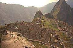
News, events, and topics about the trip to Machu Pichu,
Peru, and the boat trip down the Amazon, May 18 thru June 2,
2001. To have an item added, e-mail the specifics to John Conover, or
distribute it via the mailing list.
Upcoming events:
Past events:
Saturday May 5th, 2001. The Rancho
hike. Great hike but hot! I did the contour map and we went
10 miles and elevated 1000 feet! Amazing! Pictures
were from Layard. Saturday April 21st, 2001. Met at the
Castle Rock parking lot at 9AM. Castle Rock State Park. Took
Highway 9 out of Saratoga to Skyline (Hwy 35) and turned
left. Castle Rock is about 2.5 miles down Skyline, on the
right. The park covers 3600 acres with over 30 miles of
hiking trails. Castle Rock itself is less than half a mile
from the parking lot, Castle Rock Falls is about a mile
distant. Other trails will take you toward the
Saratoga-to-the-Sea Trail, or Castle Rock Camp. The where to
go when you get there, but don't wait for the Kirbys were in
Seattle. Marilyn Howard has dead tree media
pictures. Saturday April 7th, 2001 The votes were for
a Mount Umunum hike in the Mid-Peninsula Regional Open Space
District. Pictures
were from Layard. Thursday March 29th, 2001. Dr. Richard
Thompson of Travel
Medicine and his wife were our guests for dinner at
"Chevy's" at Town and Country Center in Sunnyvale. It is on
Mathilda Ave. We will meet at 6:30 pm. Dr. Thompson had a
copy of our itinerary. He let us know what immunizations
are recommended and also will tell us about what we will
need in the event of altitude sickness...etc. Saturday March 24th, 2001. Hope springs
eternal... was a rescheduled version of our rain-cancelled
hike in the Forest of Nisene Marks. We met at Adrianne's on
the morning of the 24th. We left there at 8:30, so for you
social types... had to get there any time after 7:45 for
coffee and chatter. For you sleepy heads... you waved
goodbye if you wer not there for our 8:30
take-off. Directions: drive to Santa Cruz and head south
toward Aptos on Highway 1. Turn left on State Park Drive,
right on Soquel Dr., and watch for Aptos Creek Road. Just a
reminder... this was anticipated to be a wet hike, including
creek walking, so everyone brought a change of whatever they
thought might get wet. It's a long way home if you're cold
and damp.
Pictures,
and comments by Layard: Scaling the map given to us we hiked
9.5 miles. This was not a geodetic survey map so the number
of switch backs on the map most likely were not correct as I
think there were a lot more so we most likely hiked > 9.5
miles! We started at 10:30, were at the falls around 1:30
and returned to the van at about 4:30. We had 6 difficult
creek crossings (a bunch of minor ones) and the second to
the last one stopped Adrianne. It was a bugger. The
weather was really nice and cool and over cast but no rain.
It did rain coming back on 17 between Santa Cruz and Los
Gatos. This was a tough hike. ~1000' elevation
change. Saturday March 10th, 2001. Pinnacles
National Monument. East of the Salinas Valley in the
remains of an ancient volcano, Pinnacles National Monument
consists of 24,000 acres of unique land renowned for the
beauty and variety of its spring wildflowers. It is
spectacular in its vistas of spires, sheer-walled canyons,
massive monoliths, and talus passages resulting from years
of tectonic plate movement. Open year-round, it is divided
by hiking trails into East and West districts. Our hike We
met at Adrian's at 8:30 to car pool. Pictures,
were taken by Layard. Saturday Feb 24th, 2001. Forest of Nisene
Marks. Because that is a bit farther away, we met at
Adrianne's to car pool at 8AM. For those who drove straight
to Aptos, met at 9AM. Directions: Drive to Santa Cruz and
head south toward Aptos on Highway 1. Turn left on State
Park Drive. Turn right on Soquel Drive. Turn right on
Aptos Creek Road (Word has it that this may be a bit
hard to find, so PAY ATTENTION!) Once on Aptos Creek
Road, look for a parking lot on the right side of Aptos
Creek Road. Meet at the parking lot at 9AM.Pictures,
of course, were taken by Layard. Saturday Feb 17th, 2001. February birthdays
for Patti and Connie. Pictures
were taken by Layard. Saturday Feb 10th, 2001. Sawyer Camp Trail.
A narrow, winding, 6 mile long paved trail (with optional
extension at the north end) through San Francisco watershed
lands. Views of Crystal Springs Lakes. This lush,
frequently deer-filled bit of woodland belies its proximity
to 280 and our fast-paced civilization. Directions: 280
north to Bunker Hill Drive exit, cross over the freeway,
then go north on Skyline Blvd past Crystal Springs Dam to
the entrance gate. Parking is on the side of the road. Pictures
of the Sawyer Camp hike were taken by Layard. Sunday Feb 4, 2001. Three runners and seven
walkers spent a brilliantly sunny Saturday taming Almaden
Quicksilver Park. Our group swelled to include Cathy and
Mary (Cathy of Cathy and Steve who will be going to Peru in
May). As you probably saw from the pictures, we had a great
hike and only got lost a couple of times. Saturday Jan 27th, 2001. Hiked (part of) the
Almaden Quicksilver trail. Meat at 8AM. There were 25
miles of trails, many following old roads that lead to the
mercury-producing cinnabar ore mines that were once the most
productive quicksilver mines in the world. A mining Museum
at 21570 Almaden Rd is open Saturdays from 1-4. Directions:
There are 3 entrances: Almaden Road, Mockingbird Hill, and
McAbee Road. We met at the Almaden Road entrance: Almaden
Expressway to Almaden Rd & go 1 1/2 miles on Almaden Rd
to the park entrance. Pictures
of the Quick Silver hike were taken by Layard. Saturday, Jan 20, 2001. January Birthdays:
Joined in the celebration for Adrianne, Roger, and Tim at
Marilyn Morris's house on Sat Jan 20th at about 7PM. Layard
took many pictures. Saturday, Jan 13th, 2001having declined our
breakfast pizza, but replete with homemade bread and fresh
ground coffee, a group of 8 piled into a 7 passenger van and
departed for Rancho and the first scheduled Peru
conditioning hike. We had a cool, sunny day, and a
comfortable 3 1/2 hour hike along the PG&E trail.
Trailside photos
documented our progress, and new hiking gear was
tested. Watch out Peru... we'll be ready! Monday, Jan 1, 2001. Met at 10:30 AM in the
parking lot of Ohlone College to hike Mission Peak. Dressed
warm. Brought food and libation to share at the top. A good
time was had by all, and Layard took many pictures. Sunday, December 31, 2000. New Year's eve
at the Conover's. Tim and Connie made enchiladas for dinner,
and the New Year was ushered in with libation and spirits.
Layard chronicled the event with a few pictures.
|